Interactive Website Tells Story of HRT’s Impact on the Region
5/4/2026
Hampton Roads Transit (HRT) launched a new interactive website—Sustaining the Future of Transit—that highlights the agency’s history in Hampton Roads, VA, and its economic impact on the second-largest regional economy in the state. In addition to the communities that live in the area, Hampton Roads is the location of national and international industries, a large military presence (including the world’s largest naval base), and the deepest port on the East Coast.
The “Story Map” blends narrative with maps, photos, and video to show how public transit connects people to jobs, education, healthcare, and key destinations across the region. It includes:
- Interactive maps highlighting routes, points of interest, employment clusters, population density, and where transit demand is strongest
- A timeline of the history of transit in Hampton Roads
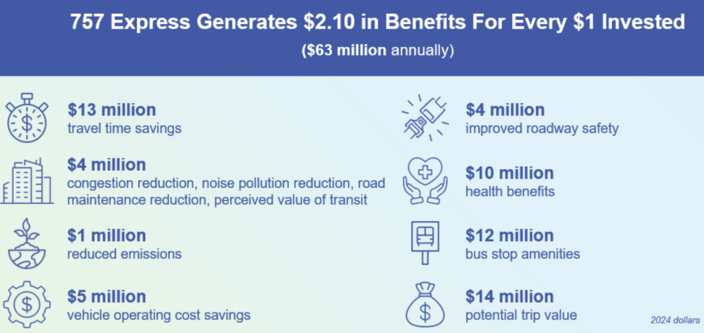
- Data on HRT’s economic impact, including the fact that the HRT 757 Express service generates $2.10 in benefits for every $1 invested
- Videos from local leaders in industries—such as the Naval Station Norfolk, hospitals, and hospitality sector—whose workforce rely on transit
- Challenges and opportunities facing the agency, including making the case for long-term, sustainable funding
The website frames public transit as an economic development tool. HRT’s services support local jobs and wages through day-to-day operating and capital spending, while also helping employers reach a broader labor pool by providing reliable access to worksites for people who do not have—or prefer not to use—a personal vehicle.
The online resource supports HRT’s efforts to secure dedicated, sustainable transit funding and complements initiatives, such as the System Optimization Plan, which is focused on improving efficiency and reducing costs.